Posts

Showing posts from 2018

At least forest fires eventually burn out

Image
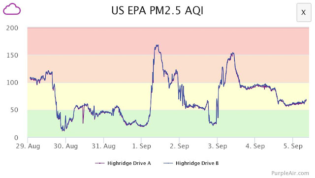
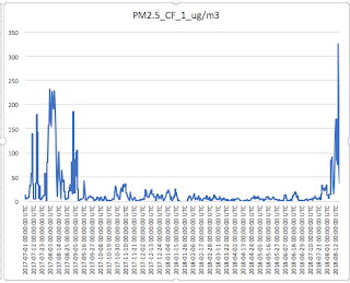
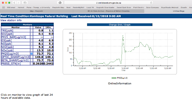
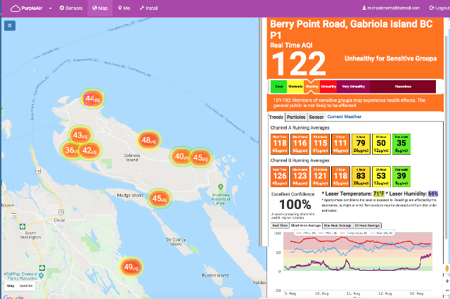
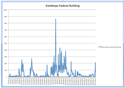
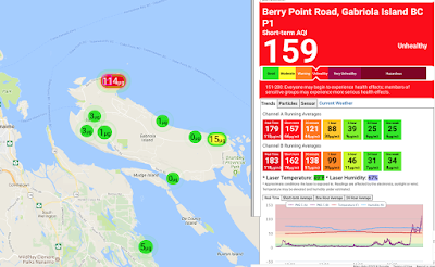
For those who experienced a Summer exposed to wood smoke from forest fires, the thought of yet another Fall, Winter, and Spring filled with locally-produced wood smoke from fireplaces and wood stoves is a horrifying one. Many are now exposed to particulate pollution for virtually 12 months of the year, and in rural and semi-rural communities these exposures are usually higher and almost never recorded by local, regional, or national governments. Our PurpleAir network shows the impacts of larger scale fire events as well as hyper-local impacts associated with residential wood burning practices. The pattern of smoke generated is clear and easy to interpret. Below is ambient air pollution from forest fires over the past week. This PurpleAir sensor is located in the Kamloops region. This pattern of smoke has a roller coaster appearance, and in this case PM2.5 reached around 165 on the US EPA AQI scale. Below is a screen capture from our network showing a range of readings from

Is the indoor air quality at Thompson Rivers University in Kamloops safe?

Image
Forest fire activity in the Province of British Columbia and elsewhere during the Summer of 2018 has once again raised concerns about air quality and human health impacts. Although the Summer of 2017 had longer and more intense wood smoke pollution events in communities like Kamloops then this year, this Summer has seen larger spikes in pollution. For a comparison of the two summers and for a discussion on the implications of multiple years of smoke exposure, click here . On August 23, 2018, smoke in the City of Kamloops returned with a vengeance. The provincial air monitoring station at the Federal Building in downtown Kamloops recorded a one hour average for PM2.5 of 231.1 micrograms/m3 at 10PM. Our PurpleAir network showed almost exactly the same levels across the "swarm" of low-cost sensors setup in the city. To learn more about how this technology compares to expensive government monitoring stations, click here . Additional examples comparing the network to sa

A "swarm" of low-cost sensors showing differences in air quality

Image
Just as quickly as the air pollution tanked into the hazarous zone this past week, it has rebounded over the past few hours. Here's an example from our network of PurpleAir sensors on Gabriola Island of this rapid improvement, and escape (perhaps temporarily) from the forest fire woodsmoke blanketing much of the province. Is the air quality on Gabriola Island good right now? It depends on where you are. Note the air pollution stratification with parallel poor readings on Vancouver Island. This is only a difference of around 5km (North to South).

How does the Summer of 2017 compare to this Summer so far?

Image
While much of BC is blanketed with wood smoke from forest fires raging across the province and elsewhere, there are some parts of the province that have been hit with bad air pollution more than others. This is due in part to terrain, proximity to forest fires, and other factors. Although our network of PurpleAir sensors is rapidly expanding across the province, the highest concentration is currently in the Kamloops area. Kamloops has had two back-to-back bad summers with smoke affecting the community. How does the Summer of 2017 compare to this Summer? Below are graphs from two of our many PurpleAir sensors in Kamloops dating from July 1, 2017 to August 22, 2018. We have selected one sensor at an intermediate elevation in the city (Hugh Allan Drive) and one at a lower elevation (Moody Ave) to show you some trends. The data is based on 24-hour averages, and it's worth noting that the provincial 24-hour average target for PM2.5 is 25 micrograms/m3. We believe that this t

Why is our provincial government and local health authorities downplaying the risks associated with PM2.5 exposure?

In the August 15, 2018 issue of Kamloops Info News , it was suggested that exposure to PM2.5 from forest fires isn't a big deal and that the kind of air pollution generated by it is somehow less dangerous than exposure to smog found in larger cities. Although the amount of fine particulates currently in the air is comparable to large metropolitan cities with air quality problems, Ayache says the fine particulates in the Kamloops and the Okanagan are largely a result of the forest fires and don't contain a multitude of toxins you would find in a smog filled city. ( B.C. Ministry of Environment air quality meteorologist Tarek Ayache). This is complete and utter nonsense. PM2.5 from combustion of biomass (forest fires, wood stoves, biomass-based energy systems etc) contains hundreds of toxic chemicals that are bound to the surface of particulates. Many of these are highly carcinogenic and create acute responses including heart attacks and strokes. They have also been found to

Comparing graphs of air pollution in Kamloops - Provincial monitor versus PurpleAir

Image
The low-cost PurpleAir network acts like a "swarm" to provide more detailed data - at various locations - on air quality. The strength of this approach is to use all sensors in a region to understand more fully how air quality varies by elevation, proximity to a pollution source, and other factors. It's also very helpful to have multiple readings from independent devices. Here's another example of how the technology compares to the provincial air quality monitoring program. This example is a snapshot of several days of averaged data which compares the provincial monitor in Kamloops to the closest PurpleAir sensor. Note how the trend lines track each other.

How to control your exposure to wood smoke during forest fire events

Image
People sometimes take a laid-back approach to air pollution and often underestimate how both short term and long term exposures add up to health risks that can be serious. Heart attacks and strokes are much more common during high pollution days (and immediately afterwards), and particulate matter at the 2.5 micron scale (PM2.5) can accumulate in our blood stream and move into various organ systems causing damage from oxidative stress, inflammation, and other processes. With forest fires and ambient air pollution generated from non-point sources, there's sometimes a perception that nothing can be done to minimize exposure and that we should just get on with things. We sometimes hear comments like, "There's nothing we can do about it." The most important and successful way to reduce exposure to forest fire smoke is to stay indoors as much as possible, close windows, and to use air purifiers with HEPA 5-stage filtration. Here is some data from today on the ef

Still doubt the accuracy of low cost air quality monitors?

Image
Today, local forest fire events have triggered extremely high air quality readings in Kamloops BC. For more than two years the BC Ministry of Environment and others have been raising doubts about the quality and accuracy of citizen science networks like PurpleAir. They have issued statements to media, city councils, and other branches of government calling this equipment cheap smoke detectors that are Made in China. It's an inconvenient truth for them when smoke problems catch them with their pants down. Today the Air Quality Health Index lagged several hours in telling people in the community about the real risk. They had their index at a low risk level of 3 out of 10 when it was clear from our readings beginning at 3AM that this was a dramatic underestimate. The same thing happened all of last Summer in the region with incredibly high levels of risk to the population that were systematically downplayed. Here's (yet again) proof that these devices work - and they work

Comparing PurpleAir network accuracy to satellite data from Copernicus

Image
For those who question the value and accuracy of low cost particle sensors made by PurpleAir and other companies, consider this evidence. Here we have PM2.5 satellite predictive modelling from the Copernicus open access database of surface PM2.5 for North America (note the hot spots likely from forest fires). When we compare a map of real-time sensors from PurpleAir it should be immediately apparent that they agree with the satellite models in general ways. If you need more specific proof, the satellite estimate is giving a current surface PM2.5 reading of 33 micrograms/m3 and the PurpleAir sensors on Gabriola Island are bang on! What's puzzling and somewhat disturbing is the inaccuracy of the air quality monitors used by the BC Ministry of Environment. Compare what their PM2.5 levels are at 15 micrograms/m3 in nearby Nanaimo to what the Copernicus satellite indicates at 39 micrograms/m3. This holds even when one takes into consideration the realti

How does indoor air pollution compare to outdoor air pollution?

Image
Many people incorrectly assert that indoor air quality is worse than what can be found outdoors. In some instances this can be true. Burning toast in the kitchen will most likely create short-term high levels of indoor air pollution, and chemical off-gassing from commonly found households products including construction materials can create hazardous environments inside your home. Mould and cigarette smoke can also contribute to this problem. Between June 6-18, 2018, we ran two separate and identical PurpleAir sensors at one of our locations on Gabriola Island. Data was averaged over a 10 minute period and ambient (outdoor) air quality was quite good this time of year with only a few instances of residential wood burning in the immediate neighbourhood. Below are the results. Each PurpleAir sensor has two built-in laser detectors, so we took the average of them to create a standardized data set. From this graph you'll note the following. 1. Outdoor air pollution is almost

A "tainted smoke" inquiry should be launched against the BC Lung Association

In the late 1970s, blood operators from around the world began to panic as vulnerabilities in their risk management systems were exposed due to the global spread of new and difficult to detect pathogens. As a result of these failures, thousands of Canadians were infected with HIV and Hepatitis C from blood and blood products. In Canada, the Canadian Red Cross Society ran the blood system until it was dismantled following recommendations from the Royal Commission of Inquiry on the Blood System in Canada which was led by Justice Horace Krever. Two new non-profits emerged to take over Canada's blood system after this 1997 report was released, and the groundwork for Canadian Blood Services and Hema Quebec were laid out by these recommendations, new insurance and reinsurance arrangements, and a new corporate governance structure with newly defined roles for the federal Minister of Health and Provincial and Territorial counterparts. The Canadian Red Cross Society made several key

BC Lung Association Is In A Conflict Of Interest Situation

For years the province's preeminent charitable organization for all things respiratory, the BC Lung Association, has been receiving money from the provincial government to administer a flawed program to exchange wood stoves. As we've stated elsewhere on this blog, EPA wood stoves are not the answer and emit massive amounts of particulate and other kinds of pollution that contradict the efforts of BC Lung and others to protect public health. By putting their name and team behind the wood stove exchange program, BC Lung is jeopardizing the health of thousands of people. We strongly recommend that they discontinue their support of this program and speak out against all kinds of wood burning practices. One can hardly support lung health research while at the same time willingly and obstinately ignoring a major exposure pathway to lung and heart disease. An earlier call for action provides more details. See here . According to a Senior Air Quality Scientist with the BC Min

Comparing PurpleAir Sensors With Expensive Government Monitors

Image
During the Summer of 2017 the interior of British Columbia experienced an unprecedented forest fire season with wood smoke bathing much of the province in particulate pollution. In Kamloops and elsewhere, community groups and individuals have been setting up low-cost air quality sensors made by companies like PurpleAir and more recently SensorUp . How do these sensors compare to government air quality monitors which often cost hundreds of times more? Below is an overview comparing three of several PurpleAir sensors in Kamloops to the government monitor located on the Kamloops Federal Building with respect to PM2.5 levels during the months of July and August 2017. For comparison purposes, two PurpleAir sensors are within 1km of the Kamloops Federal Building. Here's what the government monitor yielded during this timeframe based on a one hour averaging period. Below is the same averaging period for the PurpleAir sensors located on Lorne Street and Strathcona Terrace

The story of two Gulf Islands: Thetis and Gabriola

Image
Today the following two screenshots of air quality on Gabriola Island (Berry Point Road) sensor and Thetis Island show dramatically the impacts of wood stoves on air quality. Both sets of data were captured at 7PM on April 5, 2018. Thetis Island has a population of 350. It has no industry, minimal traffic and the centre of the island is 13.5 km from the Crofton Pulp and Paper Mill.  Thetis is almost due north at 174 degrees from the mill. At this time, the air quality at the sensor's location is excellent and consistently low over various averaging periods. You should note that the bottom line in the graph is flat indicating no significant sources of wood smoke or other particulate pollution. By contrast, Gabriola Island has a population of 4000 with many households that use wood for home heating. Like with Thetis Island, there is no industry and minimal vehicular traffic on Gabriola. The distance from the sensor on Berry Point Road to the Harmac Pulp and Paper Mill in Nan

Will this insanity end?

Image
This evening one of our sensors on Gabriola Island began picking up rapidly increasing levels of wood smoke in the Berry Point Road area. These levels are more than 10 times the World Health Organisation's limits and represent a real and immediate threat.